© René Poccard-Chapuis
Territorial certification and efficient landscapes in Paragominas, Pará
The colonization of Paragominas began with construction of the Belém-Brasília railway, which was inaugurated in 1959. The township’s founder, Célio Miranda, began distributing 4,000-hectare parcels of land, which are still the framework for land ownership in the region.
Paragominas’ first economic cycle was based on beef cattle farming, driven by the “colonization by the hoof” policy. Those who came to live here, mostly from Brazil’s Southeast, soon realized that there were riches in the forest, highly dense in commercially valuable species like hardwoods.
© René Poccard-Chapuis
The following decades brought the consolidation of an extractive economy in which the income produced by logging was invested in more deforestation. The rapid degradation of the forests and the pastures led to a collapse in the 1990s.
A new productive cycle then began with the adaptation of industrial grain farming which was only interrupted in 2008 by the “Arco de Fogo” [Arch of Fire] operation, part of the Federal Amazonian Deforestation Combat and Prevention Plan (PPCDAM). In response to this “command and control” policy, Paragominas policy makers created a new environmental governance model based on a pact between the public and private sectors which became known as Município Verde [Green Municipality].
While forestry management has improved in the region, this governance model has not managed to leverage essential effects such as the restoration of degraded areas or the reduction of fire risk. Characteristics of previous economic models remain alongside cluttered landscapes, activities that do not consider readiness of the soil, fragmented forests and intensification of the resulting droughts.
TERRITORIAL INTELLIGENCE IN PARAGOMINAS
In 2012, researchers from The Center for International Cooperation in Agronomy Research (CIRAD) at Amazonia Federal University (UFRA), The Brazilian Agricultural Research Corporation (EMBRAPA) and Pará Federal University (UFPA) joined forces to perform an agrarian diagnosis in Paragominas. Their conclusion was that the brake on deforestation achieved by the Green Municipality pact did not lead to alternative farming systems able to promote sustainable development. Small farmers remained at the margins of the farm economy and of territorial development, resulting in a need for innovative solutions.
© René Poccard-Chapuis
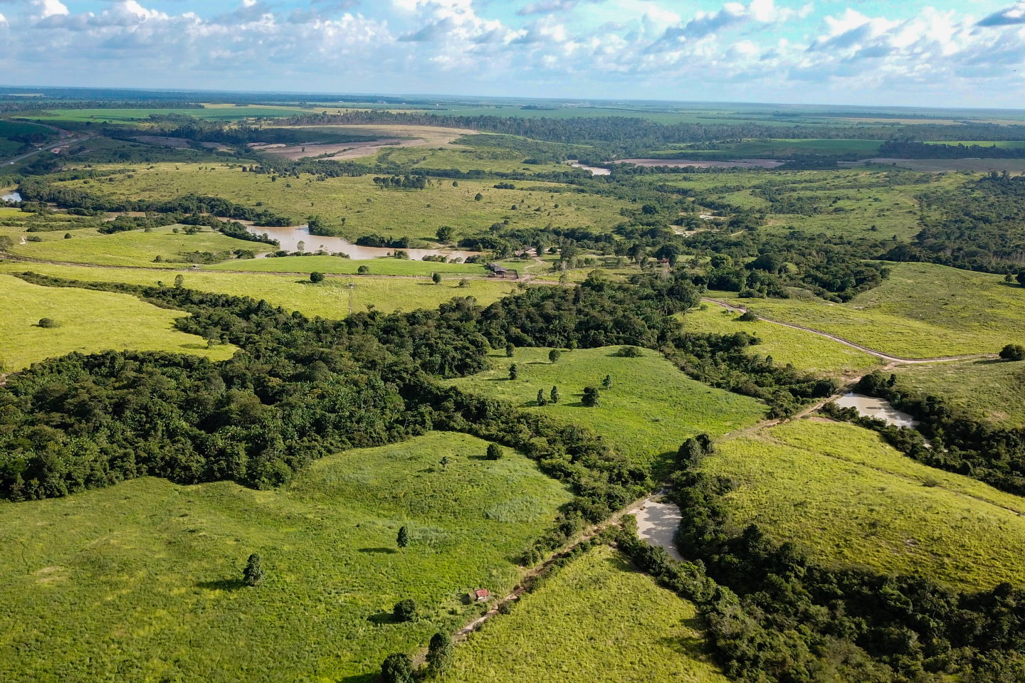
Paragominas had emerged from the years of uncontrolled deforestation with fragmented forest that is vulnerable to drought. The sparse and cluttered state of the standing forest was not favorable to the production of ecosystem services and therefore could neither protect the soil and the biodiversity, nor regulate the regional climate.
Agricultural and cattle farming regions were not always located on land appropriate for mechanization, fertilization and irrigation, at the cost of efficient resources management and generation of jobs and income.
THE ACTIONS
The Paragominas Territorial Accompaniment project was born out of interactions between the social stakeholders and culminated in the creation of the Territorial Intelligence and Development Plan instituted by the City Hall, the Plan’s main partner.
Sustainability is a central value in the methodology that should be defined by stakeholders inside the territory, not external parties or global definitions.
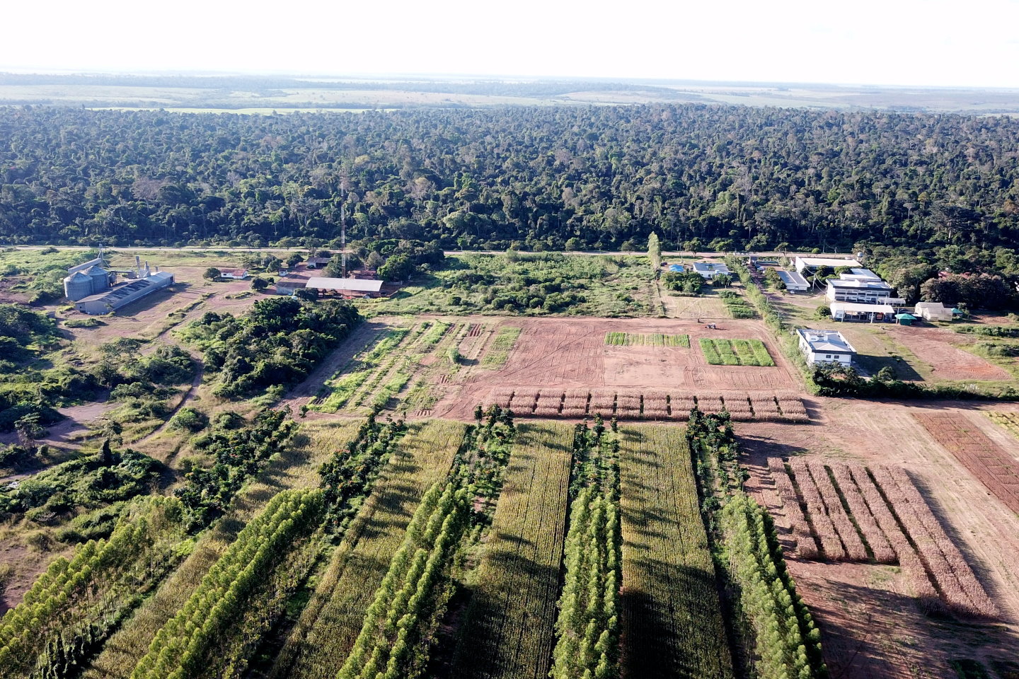
Another important component of the process is to rethink the spatial organization of the agricultural model and the forestry model. One goal was to identify the activities that would be the most efficient in already deforested areas in order to intensify farming and cattle raising in these spaces so as to promote sustainable development.
© René Poccard-Chapuis
It can be seen that the more rural producers invest in more intensive practices and managed systems, they will concentrate their use of land on the most suitable areas. When this happens, parts of the landscape are left over for forest regeneration. The intensification and verticalization of farming systems promotes this dynamic and is driven by two management tools: a geographic information system that maps out suitability and uses, and municipal micro-zoning, which regulates environmental and production management according to the maps. This territorial intelligence help the region accelerate the landscape reconstruction process.
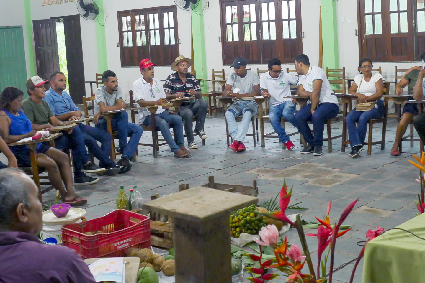
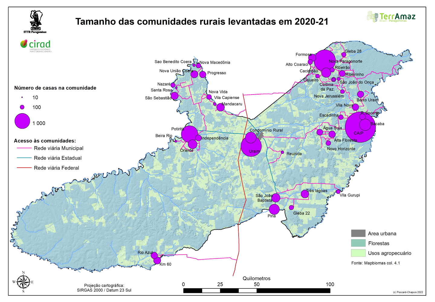
Aside from the landscape, rural communities are also bases for sustainability in Paragominas. However, as is usual in Amazonia, they are not included in territorial management, which ends up reinforcing damaging dynamics like rural exodus, food insecurity and land insecurity. The importance of communities must be recognized and instituted within the territory so that they may become vectors for social and productive organization, which improves the quality of life of all. A broad activity program was developed, including leadership training, the creation of a forum for the communities, training sessions on innovative practices and participation in the definition of the City Master Plan through these actions:
-
- Completion of a thorough initial diagnosis of the entire territory including all social groups. This diagnosis is continually updated. The diagnosis began with 243 questionnaires in 16 communities, and all of the municipality’s 46 communities are being monitored.
- Development of technical and organizational training sessions involving farmers and support services. In Paragominas, the focus is on green cattle raising, farming without burning and cocoa production.
- Construction and establishment of collective discussion spaces, especially among smallholders in order to combat institutional isolation. The Rural Community Forum was established and by 2021 had held six different series on topics like agroecology, solidary economy and environmental regularization, in addition to the construction and discussion of territorial scenarios.
- Production of maps for territorial organization with the aim of helping public and private administrators make the best decisions and monitor the territory’s performance. The project led to a map of the best uses for different soils and spaces throughout the entire municipality. Priority areas for forest restoration and intensified farming and cattle raising were mapped out. Measurements and monitoring of ecosystem services related to the water and carbon cycles, biodiversity and soil protection were also carried out.
City Hall set its objective to use these maps as a basis for reorganizing the territory. In other words, the maps will be used by City administration to validate Environmental Regularization Programs, environmental licensing and other processes.
© René Poccard-Chapuis
THE RESULTS
The most significant innovation resulting from the project is the establishment of a territorial certification system.
This certification will verify the territory’s sustainable development in a transparent manner and according to reliable criteria. In assuring that the established uses within the territory are economically sustainable, the certification will make Paragominas a more attractive locale for investors able to bring resources to the process.
One of the pillars for certification is monitoring soil usage in order to reinstate a forestry model (for the production of ecosystem services) and a farming and cattle raising model (for concentrated production in the best suited areas). Another pillar is the consolidation of rural communities, where leadership should be strengthened and the involvement of local smallholders in territorial administration be encouraged.
Other results of the project:
-
- Creation of a territorial development plan for Paragominas. Ratified by municipal decree in 2019, it confirms the possibility of combining economic and environmental goals for sustainable development in the territory.
- Definition of financial, logistical and scientific support from the French Development Agency so the municipality may carry out its plan within the TerrAmaz project. TerrAmaz supports the transition of Amazonian territories to sustainable development models that are free of illegal deforestation.
- Creation of an online map platform to spread information on the dynamics of the township’s landscape and ecosystem services.
- A group of neighboring townships are planning to establish an association to expand the same methodology developed in Paragominas so a territorial certification can be established for an even larger area. The association includes the municipalities of Abel Figueiredo, Rondon do Pará, Dom Eliseu, Ulianópolis, Ipixuna do Pará, Bom Jesus do Tocantins and Paragominas.
PROJECTS
-
- Public and private commitments to zero deforestation (2018-2021), financed by CGIARS
- TerrAmaz (2020-2024), financed by AFD
- Sustenta&Inova (2022-2025), financed by the European Union
PARTNER INSTITUTIONS
FINANCING

PUBLICATIONS
Mapping land suitability to guide landscape restoration in the Amazon. Poccard-Chapuis R., Plassin S., Osis R., Pinillos Cifuentes D.A., Martinez Pimentel G., Cordeiro Thalês M., Laurent F., De Oliveira Gomes M.R., Ferreira Darnet L.A., De Carvalho Peçanha J., Piketty M.G.. 2021. Land, 10 (4) : 23 p. DOI: 10.3390/land10040368
Understanding landscape multifunctionality in a post-forest frontier: Supply and demand of ecosystem services in Eastern Amazonia. Pinillos Cifuentes D.A., Bianchi F.J.J.A., Poccard-Chapuis R., Corbeels M., Tittonell P., Schulte R.. 2020. Frontiers in Environmental Science, 7 : 16 p. DOI: 10.3389/fenvs.2019.00206
Lessons for jurisdictional approaches from municipal-level initiatives to halt deforestation in the Brazilian Amazon. Brandão F., Piketty M.G., Poccard-Chapuis R., Brito B., Pacheco P., Garcia E., Duchelle A.E., Drigo I., Carvalho Peçanha J.. 2020. Frontiers in Forests and Global Change, 3 : 14 p. DOI: 10.3389/ffgc.2020.00096
Spatial determinants and future land use scenarios of Paragominas municipality, an old agricultural frontier in Amazonia. Osis R., Laurent F., Poccard-Chapuis R.. 2019. Journal of Land Use Science, 14 (3) : p. 258-279. DOI: 10.1080/1747423X.2019.1643422